
Friday, December 29, 2017
Maps: Lyndon to Summit Tunnel
The scenic ride along Los Gatos Creek between the southern end of Cats Canyon and the western portal of the Summit Tunnel (Tunnel #2) lacked none for aesthetic beauty. For 5.2 miles, the South Pacific Coast and, later, Southern Pacific meandered up the valley, primarily staying to the east of the creek but twice venturing to the opposite side. For such a short span, a surprising number of stations and stops appeared, both for freight and for passengers, and for the first thirty years of the railroad's existence, this stretch acted as the playground for Bay Area elites wishing to spend an afternoon in the redwood groves and grassy meadows of the Santa Cruz Mountains. Now, a third is inundated under Lexington Reservoir and the rest is situated within the lands of the San Jose Water Company.


Friday, December 22, 2017
Tunnels: Summit (Tunnel 2)
Legends whisper about it. Ghosts haunt it. Gas leaks from it. And rumor plagues it. Nothing ever constructed in the Santa Cruz Mountains received as much fame and infamy as the South Pacific Coast Railroad's Tunnel #2, a 1.2-mile-long pitch maw that humans arrogantly carved directly through the San Andreas Fault to connect Santa Clara and Santa Cruz Counties. Mother Nature was displeased with the railroad in 1880 and fights even today to erase all trace of this presumptious hole bored directly through the heart of the mountains.
 |
| South portal of Summit Tunnel, crossing Burns Creek, c. 1882. [Bruce MacGregor] |
When the South Pacific Coast first drafted its plans to build a railroad between Alameda Point and Santa Cruz, management knew that they would have to go through the mountains somehow, but they waited and delayed and hesitated until mid-1878, when grading crews demanded a final alignment. Initially intended to pass into Soquel Canyon via a smaller tunnel to be located further up Los Gatos Creek so as to descend to the city of Santa Cruz via Soquel, railroad superintendent Alfred "Hog" Davis negotiated a deal with Santa Cruz entrepreneur Frederick A. Hihn and lumber magnate William P. Dougherty in September 1878 to divert the railroad to the San Lorenzo Valley first via a longer route through the Upper Soquel, Bean, and Zayante Creek watersheds. Rather than requiring a single tunnel through the mountains, the new route required four including two monstrously long ones, the longer of which would briefly hold the record for longest railroad tunnel in California. That Goliath of engineering was the Summit Tunnel.
 |
| Clearing out mud from the western (Wright) portal of the Summit Tunnel after a heavy rain, c. 1890. [Bruce MacGregor] |
Construction began in October 1878 under the direction of Edward H. Mix. Around 100 Chinese workers were brought in to mine the tunnel from both sides of the bore and small camps developed at both sites. On the northern end, the worker camp developed into Wright, especially once freight and passenger service began coming to the location around spring 1879. On the other side, above Burns and Laurel Creeks, the town of Highland developed, where workers for both the Summit and the Glenwood Tunnel lived, as well as lumbermen who harvested and cut lumber on behalf of the railroad and Hihn. A steep switch-back road was built above the northern portal (today's Wrights Station Road) and over the ridge to Highland along what became Schulthies Road. Additional roads were extended off the San Jose-Santa Cruz Turnpike to Wright and off Mt. Charlie Road to Highland. Meanwhile, grading crews worked to install track to Wright and prepare the ground for track in the Highland area. All was proceeding as planned.
 |
| Reconstruction of the western portal of the Summit Tunnel, spring 1893. [Bruce MacGregor] |
Throughout its existence, the Summit Tunnel had three significant problems—flooding, natural gas, and the San Andreas Fault—each of which will be addressed in turn. Ed Mix anticipated the first problem and designed the entire tunnel to slope gently downward from either side. It was an intelligent move that protected the tunnel interior from ever suffering heavy condensation or erosion. What Mix did not anticipate, though, was the intensity of water flowing down the gully above the tunnel at Wright. For whatever reason, surveyors had chosen to place the tunnel directly at the base of a steep gully that seasonally had significant amounts of water flow down it. Every winter for the first fifteen years of its existence, water poured off the top of the tunnel portal, silting the tracks and often throwing heavy debris below.
 |
| Work crews putting finishing touches on the new concrete western portal of the Summit Tunnel, 1893. [Bruce MacGregor] |
The winter storm in 1893 was unusually bad and the entire portal at Wright collapsed. Early that spring, crews moved in and cleared the tunnel but the decided against rebuilding the wood-frame portal, opting instead for a complete overhaul. They widened the portal to standard-gauge, anticipating the line's upgrade a decade later, and used concrete rather than wood to reinforce the entrance. Furthermore, they installed a large spillway beside the portal to redirect the flow of water away from the mouth of the tunnel. This worked extremely well and the portal survived the San Francisco Earthquake in 1906 and remained in use until the closure of the line in 1940. Unfortunately, when the Army Corps of Engineers dynamited the tunnel in April 1942 on behalf of Southern Pacific, the structural integrity of this older portal did not hold. The entire concrete face fell forward and has been sinking deeper in to the mud ever since. The only part that remained was some of the concrete frame inside the tunnel and half of the adjacent spillway. It remains the only one of the eight railroad portals in the mountains to be lost. Adding insult to injury, Mother Nature has reclaimed the tunnel since the portal's structural collapse and the seasonal gully now runs freely over the top of the tunnel remains and onto its debris pile below. Nature destroyed the tunnel once and humans vainly attempted to holder her back, but she has once again reclaimed it.
 |
| The remains of the western portal of Summit Tunnel, 2000s. [Brian Liddicot] |
The other two problems that plagued the Summit Tunnel were unexpected. On November 16, 1878, after only a month of drilling, work crews discovered methane gas in the western end of the tunnel. Even as more workers passed out from overexposure, others began discovering coal deposits and oil spots on the ground. Workers began carrying lit candles and torches into the tunnel to burn off the natural gas, but a number of accidents occurred when workers returned after holidays, work stoppages, and Sundays. By January 1879, crews worked in utter darkness and no further effort was put to discovering the specific source of the gas leak. This was a tragic mistake. On Valentine's Day, an explosion shook the mountain and people began fleeing the tunnel, some aflame. Fourteen Chinese workers died and many other workers were severely burned. Work on the tunnel stopped for three months to search for solutions. Eventually, a new Chinese work crew was brought in (the old refused to return to the tunnel) and pipes were installed to pipe fresh air into the tunnel in the hope that the methane would be pushed out the front. Nonetheless, another incident occurred in June when a creosote-treated redwood beam caught fire and burned for two months. The fire spread to other beams and caused a cave-in, leading to another two-month delay.
 |
| Chinese worker standing outside the worker barracks near the Summit Tunnel's western portal, c. 1880. [Bancroft Library] |
The most notorious incident, however, was that of November 17, 1879. On that date, crews were working in the tunnel when an explosion shot out of the portal like a cannon. Off-shift workers ran into the tunnel to pull out their friends, but another explosion erupted shortly afterwards. According to sources at the time, thirty-two Chinese laborers died that day. Tunnel construction came to a stand-still on both ends and Cornish workers from the New Almaden Quicksilver mines were eventually brought in to finish the job on the Wright side. By this point, the source of the methane leak was discovered and a pipe was hammered into the leak and a lantern installed to keep the gas burning. Electric lighting was also installed overhead to avoid other open flames. No further incidences occurred and the tunnel was finally finished on May 10, 1880. The boring through of the tunnel inevitably aided in air circulation, providing further protection from an explosion. Regardless, when the western portal was rebuilt in 1893, the methane leak, which was not actually that far into the tunnel, was completely cemented over, thereby resolving the issue permanently. Nothing else has ever been said of the leak, but a persistent rumor exists that a seismology group attempted to inspect the tunnel for internal damage after the 1989 Loma Prieta Earthquake but quickly closed the small hole they had made at Wright when high quantities of methane gas was detected on their instruments. The tunnel may well be a ticking time bomb hiding deep in the Santa Cruz Mountains.
 |
Work crews widening and re-boring portions of the Summit Tunnel, 1906-7. [Bruce MacGregor]
|
 |
| Damage to the Summit Tunnel after the 1906 earthquake. Western portal visible in distance. [Bancroft Library] |
One thing that is certainly true is that the San Andreas Fault had no respect whatsoever for the tunnel. When the earth trembled in April 1906, it shifted by five feet within the tunnel. Like the gas deposit, the damage was largely localized to the western side of the tunnel, since the fault was only about 200 feet inside. Due to poor economic conditions after the earthquake, it took over a year to reopen the tunnel. The new structure was standard-gauge, completely re-timbered, and sported a brand-new concrete portal on the eastern (Laurel) side. A brick ceiling was also installed for roughly 300 feet on that side since the soil was primarily weak sedimentary rocks and required additional support. Because of that brick ceiling and the threat of collapse, US Army engineers decided to only blast the tunnel beyond this point, so the first 300 feet of the eastern portal remains even today as one of the most intact Southern Pacific tunnels in the county (the other being the Zayante Tunnel, which remains in use by FileSafe). That being said, it cannot be doubted that the western portal, located much closer to the fault, probably sustained further damage inside. Due to the destroyed entrance and the probable presence of methane, the current condition of the interior cannot be known.
 |
| A velocipede in the western portal of the Summit Tunnel, c. 1910s. [Bruce MacGregor] |
 |
The eastern portal of the Summit Tunnel,
c. 1930. [Bruce MacGregor]
|
In the end, the story of the Summit Tunnel is one of tragedy upon tragedy, disaster after disaster. But what people do not discuss is the fact that, from 1907 until 1942, the tunnel did its job without incident. At 6,157 feet, it was the longest tunnel in the county and remained one of the longest in the United States throughout its existence. It began life as a narrow-gauge tunnel on a relatively short-line railroad and ended as a standard-gauge tunnel on a major branch line of the Southern Pacific octopus. Each disaster strengthened it until it became impervious to most threats. Its solid redwood interior—completely replaced and upgraded in 1907—ensured its durability. Its ultimate closure and inglorious destruction in 1942 were not due to the tunnel, but due to short-sighted business decisions by an over-extended railway company. Most of the tunnel probably survives beyond its collapsed entrances, and the eastern end certainly has plenty to offer visitors even if the line never reopens. But rest assured: if the line over the Santa Cruz Mountains is reopened, the old Summit Tunnel will rise to the occasion once again and Mother Nature will inevitably fight against its survival every step of the way.
 |
| The brick ceiling of the eastern portal of the Summit Tunnel showing few signs of aging, 2012. [Derek Whaley] |
Geo-Coordinates & Access Rights:
Western Portal: 37.138˚N, 121.948˚W
Eastern Portal: 37.123˚N, 121.964˚W
The site of the western portal of the Summit Tunnel is easily accessed from the bottom of Wrights Station Road, which is off Morrell Road on Summit Road. Just before crossing the bridge over Los Gatos Creek, the path to the portal can be found. Look for mailboxes and follow the short trail up the gully. The portal cannot be missed. Visiting this tunnel, however, is considered trespassing by the San Jose Water Company and they will ticket any vehicles it finds parked within their area. You have been warned!
The site of the eastern portal is currently unavailable to the public by special request of the owner. In any case, the tunnel was partially flooded in the January-February 2017 storms and the primary two trails to the tunnel have both suffered heavy damage and must be repaired before they should be used. The new property owners hope to allow access to the site at some point in the future. Check back on this page for future information.
Citations & Credits:
- MacGregor, Bruce A., and Richard Truesdale. A Centennial: South Pacific Coast. Boulder, CO: Pruett Publishing, 1980.
- Whaley, Derek R. Santa Cruz Trains: Railroads of the Santa Cruz Mountains. Santa Cruz, CA, 2015.
Friday, December 15, 2017
Picnic Stops: Sunset Park
 |
| A picnic train on the spur across from Sunset Park, c. 1900. Note the Japanese lanterns. The purpose of the large structure behind the train is unknown. [Vernon Sappers] |
 |
| Picnickers walking beside a train toward the swing bridge to Sunset Park, c. 1900. [Vernon Sappers] |
Southern Pacific worked hard to market Sunset Park. They cut their rates from $5.00 to $3.00 for roundtrips from San Francisco or Oakland. The excursion trains they sent to the park could each take roughly 500 tourists separated into ten passenger cars. Once at the park, the railroad would sell beer and fresh foods such as French bread, gourmet cheeses, imported cured meats, and barbecued lamb. At night, electrical lighting in the lanterns illuminated the grove while live music was performed for dancers.
Sunset Magazine, originally a marketing tool of Southern Pacific, noted in 1898:
"At Sunset Park, the pavilion accommodates with ease one thousand dancers, and among the redwood groves are romantic pathways along which, in shady nooks, permanent tables and benches are placed for the convenience of small parties."
 |
| A train parked on the Sunset Park spur, probably in its first year since there are few amenities. [Vernon Sappers] |
 |
| Locals posing beside a Sunset Park excursion train outside Wright. [Vernon Sappers] |
Sunset Park quickly got a reputation about it. Due to the ruggedness of the environment, people let their inhibitions drop. Drunkenness, rowdiness, and other societally frowned-upon activities were common at the park, and obnoxious revellers littered the entire right-of-way from Wright to Alameda in the late evenings as the merrymakers returned home. Often, conductors would literally shove the worst offenders off the slow-moving train in punishment for their lack of respect for the train or other passengers. The grove itself became quickly unmanageable as many tourists would take natural souvenirs, decimating the local flora and forcing the railroad to hire gardeners to maintain the place.
 |
| Sunset Park advertisement, appropriately shown with bottles of liquor atop it. [Bruce MacGregor] |
Southern Pacific finally decided in January 1906 to stop all such excursions through the isolated Santa Cruz Mountains in favor of a more accessible and less populated location on the New Almaden Branch. The new picnic stop, also to be named Sunset Park, was scheduled to open in summer 1906, but the San Francisco Earthquake in April of that year delayed plans somewhat. Outside Wright, the spur for Sunset Park became the new end-of-track for passenger trains while all the other spurs and sidings were repurposed for construction duty since the San Andreas Fault had shifted the tunnel six feet from its original alignment. Any thoughts of tourism to the area came to an end and the two hotels in town were both turned into tunnel worker dormitories.
 |
| Overview of the area around Sunset Park, which was located just to the left of center in this photo. The large hotel built to support tourists from Sunset Park is located at right, c. 1908. Photo by Frank Herman Mattern. [Greg De Santis] |
Geo-Coordinates & Access Rights:
37.138˚N, 121.950˚W
The site of Sunset Park's spur is easily accessible. It can be found at the bottom of Wrights Station Road across the bridge to the right. Cathermola Road marks the right-of-way here, but there is no actual trace of the stop that survives. The maple grove is presumably across the creek, but all of that property is owned by the San Jose Water Company and trespassing is not allowed. Whether the original maple grove survives is currently unknown.
Citations & Credits:
- Hamman, Rick. California Central Coast Railways. Second edition. Santa Cruz, CA: Otter B Books, 2002.
- MacGregor, Bruce A., and Richard Truesdale. A Centennial: South Pacific Coast. Boulder, CO: Pruett Publishing, 1982.
- Stephen Michael Payne, "Resorts in the Summit Road Area, 1850 – 1906" (Santa Cruz: Public Libraries, 1978). From A Howling Wilderness: A History of the Summit Road area of the Santa Cruz Mountains, 1850 – 1906. Santa Cruz, CA: Loma Prieta Publishing, 1978.
- Sunset: Southern Pacific Company Passenger Dept., Vol. 1 (Southern Pacific Company, 1898).
- Whaley, Derek R. Santa Cruz Trains: Railroads of the Santa Cruz Mountains. Santa Cruz, CA, 2015.
Friday, December 8, 2017
Stations: Wright
Of all the inevitabilities that the South Pacific Coast Railroad faced on its descend up Los Gatos Creek, one was that the right-of-way would have to pass through the land of Reverend James Richard Wright, who owned an entire stretch of the creek basin north of Austrian Gulch. Fortunately for the railroad, Wright saw great opportunity in the arrival of steam to his neighborhood. Wright owned a fruit orchard and a stagecoach stop called Arbor Villa and the railroad would accomplish two things: allow him to cheaply ship fruit out of the valley and bring potential tourists to his frontier hotel. But the coming of the railroad did much more in the end—it turned the little settlement into a thriving backwoods resort area.
In 1877, grading crews for the railroad reached the area and began calculating their final path over the Santa Cruz Mountains. A gully located on the west bank of Los Gatos Creek and within Wright’s property was chosen as the site of the Summit Tunnel, the largest bore along the line. Early the next year, a Chinese labor camp was established beside the hole while a small village popped up on the opposite bank of the creek. By the end of 1878, the hamlet would include a kitchen, maintenance sheds, a turntable for the construction trains, a small saloon, a general store, smithy, and accommodations for visitors to the site. By 1879, intermixed with those official visitors were curious Bay Area tourists, who took trains from San Francisco and San José to watch the action and enjoy a picnic in the woods along the tracks to the tunnel. To support the increased traffic, sidings were added on both sides of the creek and an extra spur was installed near the tunnel. In 1879, a station structure was built near the tunnel’s portal, within which the post office for Wrights was located.
 |
| People visiting Wright on a push car, c. 1880. Photo by Rodolph Brandt. [Bancroft Library] |
 |
| The town of Wrights on a busy market day, with box cars being loaded, c. 1895. [Los Gatos Public Library] |
As soon was the tunnel was opened to through traffic on May 10, 1880, Wrights began its rapid transition into a thriving—and optimistic—resort town. Homes quickly appeared on the surrounding hills while small hotels and resorts popped up throughout the area. Across the creek at the primary settlement, A.J. Rich began construction of a new township that would place Wrights on the map. But before he even got started, the entire town burned to the ground on July 4, 1885. Within a year, new buildings sprang up on the opposite bank of the creek, beside the tunnel portal and depot, and the second town of Wrights began its life. The area became a gathering place for local farmers, ranchers, and fruit-growers to load their goods onto trains bound for Bay Area cities. A souvenir book produced by the San Jose Mercury in 1895 describes in detail this period:
The Rich Fruit-growing Section in the Surrounding Mountains. Fertile Soil and Grand Scenery. Private Residences and Summer Resorts. Natural Gas and Mineral Springs. Wrights Station, though a small village, is an important shipping point, as it is the depot for the extensive fruit growing sections in the surrounding mountains. Travelers on the cars receive little intimation from what they see along the route or at the station, concerning the rich and beautiful section which crowns the mountain above the heavy belt of timber which covers the hillside, and reaches down into the stream which rushes through the canyon. The roads which leave the little space of open ground by the depot to enter the leafy tunnels through the woods furnish no suggestion of the vine-clad slopes, the towering redwoods, the green fields, the cozy homes and bending fruit trees which adorn the great territory above and beyond. The beauty of this section can scarcely be described. There is a wealth of resource, a grandeur of scenery, and a fertility of soil that challenges description. The Great Mountain Fruit Region The amount of fruit shipped indicates in a manner of horticultural wealth of the county. There are in the vicinity about 3, 200 acres being of various varieties. The fruit raised in this section takes on a richness of flavor which is always noticeable. It is is firm in texture, also, and its keeping qualities therefore , pronounced. The in season, about two carloads of green fruit are shipped daily. The brush is being cleared from the northern side of the canyon, and the land planted to vines. When these come into bearing the output of the vicinity will be very materially increased. Soils and SpringsThe body of the soil consists largely of disintegrated sandstone and clay, and has the appearance, particularly on the hilltops, of the "white ash" soil of the Fresno raisin district. It is rich in plant food, and never lacks moisture, as the rainfall in this section is always sufficient for all needs. Springs emerge from the mountain sides in numerous places, some of which are mineral, and from every steep ravine rushes a sparkling stream. The atmosphere is always cool, influenced as it is by breezes from the coast. The Flow of Natural GasWrights Station has a resource which may yet prove to be of great importance. When the great tunnel was being driven through the mountain by the railway company a strong flow of natural gas was encountered, and an explosion followed, which resulted in the death of thirty-two Chinamen. The main leak was subsequently stopped, but gas still escapes in small quantities. The extent of the supply is unknown, but is probably great enough to warrant developments. Grand Scenery and Picturesque HomesThe scenery is everywhere beautiful, and within the past few years people in search of sites for homes have climbed on mountain sides, searched out the springs, and made winding roads around the knolls, up the canyons, and to the very summits. The brush has in many places been cut away, and trees and vines cover knolls and hillsides. White houses stand on projecting points far above the canyons, or nestle in groves of trees on the benches.(From Sunshine, Fruit and Flowers: Santa Clara County and its Resources—Historical, Descriptive, Statistical) |
 |
| Photo by Frank Herman Mattern of Wright Station, 1905. [Greg De Santis] |
The final thirty years of Wright, as it was formally renamed in 1904, is a story of declining fortunes. The earthquake forced Southern Pacific to seek newer picnic areas elsewhere along their lines, shifting the focus away from the Los Gatos Creek region. Meanwhile, most locals were forced to reassess their options regarding the profitability of local agriculture and began the long process of relocating to more profitable and accessible areas of the state.
 |
| The final location of Wright depot, 1908. Photo by Frank Herman Mattern. [Greg De Santis] |
After the earthquake, few revenue and tourist trains went to Wright during this time because of the activity surrounding the repairs of the Summit Tunnel. Because of damage sustained to the tunnel, Wright’s depot was relocated across the creek and, after 1908, slightly further north on that same side of the creek.
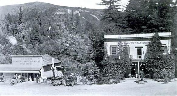 |
| Wrights Station Hotel and the Squire General Merchandise store, c. 1910. |
For the next decade, Charles Henry Squire’s general store served as the center of the town, with a hotel across the tracks from it and a few other smaller businesses and homes rounding out the community. Across the tracks, the station sat isolated across from a dilapidating pair of narrow-gauge passenger cars that had served as the tunnel repairs shops from 1906 to 1908.
Geo-Coordinates & Access Rights:
37.138˚N, 121.947˚W
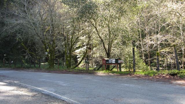
The original site of Wright’s is easy to access—it is located at the bottom of Wright Station Road, which is off of Morrill Road on the Summit. Look for the row of mailboxes, which sit roughly where the depot structure once was located. There is virtually nothing of the town left except a few concrete foundation blocks and the old bridge that has sat across Los Gatos Creek since around 1914. The San Jose Water Company patrols this area frequently so people are advised not to leave their cars alone for prolonged periods of time. While the road itself is public access, the shoulders are not. The original site of the town, across the creek, is visible across the bridge to the south. The later site of the station, also across the creek, is unfortunately now behind a razor-wire security gate and trespassing is not encouraged. Wright Station Road is now a dead-end road—the three listed roads in this area are not open to the public.
|


Friday, December 1, 2017
Bridges: Upper Los Gatos Creek
The five miles of trackage between Lexington and the Summit Tunnel at Wright was some of the most rugged terrain the South Pacific Coast Railroad encountered on their ascent into the Santa Cruz Mountains, although one must remember that there were few trees in the right-of-way since most had been logged over the preceding two decades. Besides the frequent obstacle that Los Gatos Creek presented to railroad graders, there were also numerous large and small feeder creeks that descended from the adjacent mountains and required bridges to cross. While some of these were later filled and culverted, most remained and one even survives to this day. Photographs of all of these myriad bridges do not survive, but enough exist to give an idea of the type of engineering work required of the South Pacific Coast and the Southern Pacific Railroad that followed it.
In summary, all of the bridges between Lexington and the Summit Tunnel were built with narrow-gauge tracks in mind and required upgrading by the Southern Pacific to support the larger gauge of their rolling stock. The bridges were all initially constructed in 1877 and most, if not all, were built using standard trestle designs. Trestles in the Santa Cruz Mountains were all constructed of large redwood posts, usually between three and five, held together by connecting pieces of lumber, called bents. Atop this structure sat an open redwood deck with ties and tracks. In some instances, decks alone could suffice to span a short gulch, with only abutments on either side supporting the span. In a few instances, usually where there were no firm places to install posts, a truss bridge of varying types may be installed. These essentially inverted the trestle work by lifting it off the ground. A truss is a mathematically-calculated series of bends designed in such a way to redistributed weight to the ends of the structure, which would rest on abutments or piers. In later years, many of the trestles were replaced with either fills or prefabricated open-deck plate-girder bridges which would rest on concrete piers and abutments. However, a number of redwood trestles still survived, either through upgrades or through outright replacement. Relics of nearly all of these bridges survive beyond Aldercroft.
Through the basin that today houses Lexington Reservoir, the railroad never crossed Los Gatos Creek. However, it did have a number other important obstacles to overtake. The first was Limekiln Canyon, located directly across Los Gatos Creek from Lexington. This was initially built as a standard redwood trestle and the only known photo of it is from this time. It was certainly replaced around 1900 with a studier, standard-gauge structure but whether that was a trestle or some other construction is unknown.
 |
| Limekiln Canyon trestle with the future Alma Bridge Road in the background, 1895. [Bruce MacGregor] |
Smaller bridges undoubted leapt over other small canyons and gulches between Lexington and Alma but the next significant obstacle was the Conoyer Creek—later renamed Soda Springs Creek—bridge. This was a relatively short bridge that spanned a deep gully via a standard redwood trestle. Due to the short span of this bridge, it was probably converted into a fill with a culvert during standard-gauging. The inundating of the valley in 1953 by Lexington Reservoir destroyed any evidence of this bridge.
 |
| The Soda Springs Creek bridge in the foreground with Alma in the trees behind, c. 1890. [Bancroft Library] |
South of Alma, a more problematic area was encountered that required significant trestlework. The grade ran along the eastern side of the valley but had to maintain a continuous incline to reach Wright. But a repercussion of this was that the route had to pass beside the expansive Hendrys Creek floodplain. Hendrys Creek sits today at the southern end of Lexington Reservoir (when it is full) and the canyon that causes the creek to drain is one of the widest in the region. The railroad had to build a long redwood causeway trestle across these flats to reach the solid land on the other side. When the line was standard-gauged, this bridge was simply replaced with a wider version, perhaps even keeping the old pilings in place. A proposal in 1910 would have bypassed this bridge, replacing it with two bridges that would have been situated more in the center of the floodplain, but the plan never came to fruition. After the railroad was abandoned in 1940, the bridge was repurposed to support water pipes from Lake Elsman. It remains the only intact Southern Pacific Railroad bridge in this area visible to the public without trespassing and can be viewed just to the south of Aldercroft Heights Road along Alma Bridge Road.
 |
| A modern view of Hendrys Creek trestle, 1977. [George Pepper] |
Beyond Aldercroft, explorers today enter into the restricted domain of the San Jose Water Company. It is not advised to hike through this area and it is certainly not recommended that one parks a car anywhere on Aldercroft Heights Road. That being said, remains of virtually all of these bridges survive and some are quite spectacular. Between Aldercroft and Wright, Los Gatos Creek was bridged five times, while there was also once a significant bridge over Hooker Gulch over Aldercroft Heights Road.
Following the right-of-way south toward Wright from Aldercroft, the tracks crossed Los Gatos Creek just beyond Aldercroft around a curve. This was one of the shortest crossings over the creek. What the original bridge looked like is unknown, but the standard-gauge replacement was a prefabricated open-deck plate girder span mounted atop two concrete abutments. It was probably the first or second bridge to be upgraded along this stretch owing to the older style of the abutments. At some point in the 1950s, a permanent dam was installed beneath this bridge with an accompanying concrete spillway and fish ladder which was named Rylan Dam. Clearly the water levels once were higher on both portions of this dam since the fish ladder today has no inlet and lets out on solid ground. At one time, both ends would have been submerged. When Southern Pacific crews removed the plate girder span in 1941, they left the piers and dam in place. The water company in 2010 recently built atop the piers and installed a pipe bridge in place of the train bridge, using the old foundations to supplement their additions. This addition was added through a helicopter air drop operation. Overall, the concrete remains remarkably intact leaving a beautiful scene for trespassers to find hidden in the woods of Los Gatos Creek.
 |
| Rylan Dam today, looking east, with the trestle abutments on either side holding aloft a pipe, 2013. [Derek R. Whaley] |
Less than half a mile to the south, the right-of-way passes back to the east bank of Los Gatos Creek over another bridge. The original narrow-gauge structure here was a series of truss bridges over a trio of redwood piers supplemented by wood abutments on either bank. The creek is shallower here, so the the trains would drive through the trusses rather than ride on decks above the spans. When the line was upgraded around 1901, the redwood was torn up and replaced with two hexagonal concrete piers flanked by concrete abutments that held aloft an open-deck plate girder bridge. Although the piers and abutments for this survive, the water district chose a slightly different path for their pipe from Lake Elsman and they have only repurposed the northern abutment for their uses. The other three remaining parts sit unused in the creek bed.
 |
| A crossing over Los Gatos Creek between Aldercroft and Eva, 2002. [George Pepper] |
The railroad continued to run on the east bank of Los Gatos Creek for over a mile at this point, but before it reached Eva, it crossed Hooker Gulch, a crossing which passed over not only the gulch itself, but the creek that ran down the gulch and the public road to Wright (now Aldercroft Heights Road). The construction of the original bridge is unknown but probably appeared much as the later bridge appeared. When the line was upgraded to standard gauge, a concrete abutment was built on the northern side, beside the road, and a short plate girder deck bridge was installed over the road. South of that, a trestlework causeway left to the opposite embankment, beside the creek, reuniting the line with a long fill and solid ground. Thus, this was very much a hybrid construction unlike most of the other bridges in this section of the line. The abutment still survives above the road and sawed off piers can still be followed all the way to the overgrown grade directly opposite. This is the only other bridge visible from the road without trespassing. It can be viewed by driving down Aldercroft Heights Road and looking toward the north when the road turns west suddenly through a narrow gap beside a small creek and embankment.
 |
| Hooker Gulch bridge abutment above the road, 2002. Pilings are visible opposite this spot. [George Pepper] |
The railroad crossed Los Gatos Creek three more times before making a final dramatic turn into the Summit Tunnel at Wright. All three are completely inaccessible to explorers due to the fact that they lie behind the severely protected San Jose Water Company gate and also require a good measure of bush-wacking. The first is located just past the site of Call of the Wild. It is the least photographed and very little is known about its current condition. From the scant evidence, it seems that the later iteration of this bridge had only a single hexagonal pier that has since collapsed and been ground down to nearly its foundation to allow for a modern automobile ford to be built around it. Remnant pilings on one bank suggest at least some trestlework was used to bridge the creek here, although an existing concrete abutment implies that a plate-girder bridge completed the span. Further investigation is required to determine the final structure of this bridge.
 |
| Remnants of bridge immediately south of Call of the Wild, 2002. Abutment visible in trees on hillside. [George Pepper] |
The style of the second bridge closely resembled that of the first but two hexagonal concrete piers suggest it supported a full plate girder span across the creek. The bridge brought the tracks back to the east bank to allow for a more gradual turn into the Summit Tunnel. Like the previous bridge, the piers have been left to rot, with one collapsed on its side and all evidence of the other entirely erased.
 |
| The single remaining concrete pier a bridge between Call of the Wild and Wright on Los Gatos Creek. [Brian Liddicoat] |
The final bridge between Aldercroft and the Summit Tunnel was located between the Summit Tunnel and the later location of Wright Station on the east bank of Los Gatos Creek. This is the only bridge in the Los Gatos Creek area that its entire history is known since it appears in many photographs of Wright. The first bridge was a standard trestle design without any embellishments except a footpath that ran along the northern side of the track.
 |
| The original trestle over Los Gatos Creek at Wright, c. 1880. [Derek Whaley] |
When the standard-gauging of the line began, Wright was the last place to receive an upgraded bridge. Around 1902 the original narrow-gauged structure was replaced with a sturdier bridge. The new bridge was composed of redwood timber piers and abutments which upheld a Warren truss upon which the trains would cross. Following the earthquake, a narrow-gauge service track was added to the inside curve of the bridge, replacing the footpath that originally ran beside the bridge on that side. This remained in place until 1908, when repair crews finished upgrading the Summit and Glenwood tunnels.
 |
| The bridge over Los Gatos Creek at Wright, February 22, 1907. Photo by Frank Herman Mattern. [Greg De Santis] |
Around 1910, the bridge was replaced a second time, this time with a much more modern style. New circular concrete piers were installed, reinforced with the latest quality of rebar and a open deck plate girder bridge was set atop the piers. Photographs of this final bridge seem to be lacking, probably because the popularity of Wright as a town and vacation area substantially declined following the earthquake. Nonetheless, it is this final version that survives today and is visible to those who can find them in the woods near north of the Wright townsite. A warning still printed on the base of one of the piers reads "Danger: Keep out from under bridge as rocks etc. might fall from passing train." Once an important warning for anglers and adventurers, this message now stands as a reminder that these hills were once alive with the rumbling passage of steam trains.
 |
| The two piers of the final bridge over Los Gatos Creek outside of Wright, 1977. [George Pepper] |
Citations & Credits:
- De Leu, Cather & Co., "Santa Cruz - Los Gatos Rail Corridor Feasibility Study: Draft Final Report", prepared for the Joint Policy Board (December 1994).
- Hamman, Rick. California Central Coast Railways. Second edition. Santa Cruz, CA: Otter B Books, 2002.
- MacGregor, Bruce, and Richard Truesdale. South Pacific Coast: A Centennial. Boulder, CO: Pruett Publishing, 1982.
- Whaley, Derek R. Santa Cruz Trains: Railroads of the Santa Cruz Mountains. Santa Cruz, CA, 2015.
Subscribe to:
Posts (Atom)